Early Saturday morning Sally and I set out to hike to Echo Mountain and Inspiration Point. We parked on a residential street. Parking is limited so go early unless you don’t mind a long trek on the sidewalk. The hike starts on the corner of Lake Ave and Loma Atla Dr. in the city of Altadena.

The History of Echo Mountain
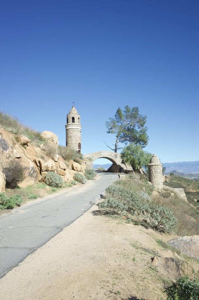
Today if you want to get to Echo Mountain and Inspiration Point you need to hike, but from 1893- 1936 you could ride on the Mount Lowe Railway. The railway was a combination of a Funicular like Angel’s Flight that took passengers up the canyon and then a narrow gauge trolley that took them to the resort at the top of Echo Mountain. It is crazy to think that in its heyday the Mount Lowe Railway was the number one tourist attraction in California. More people went to the top of Echo Mountain than Yosemite or Catalina. Ultimately, the resort burned down in 1936 and the railway tracks were damaged in a storm in 1937. Today all that is left are the ruins.


The Cobb Estate
The hike to Echo Mountain starts at the Cobb Estate which is supposed to be haunted. At one point the Marx Brothers owned the estate. They were sure it was haunted and they tore down the property. The Marx Brothers tried to build a cemetery on the haunted land, but the neighbors were opposed. Eventually, a private donation allowed the city to purchase the land.

Hiking to Echo Mountain
We started our hike by walking through the “Haunted Woods” of The Cobb Estate and luckily we didn’t feel anything weird. Our hike to Echo Mountain started on the Sam Merril Trail. It is a little over 2 1/2 miles to the top of Echo Mountain. The trail is rated as moderate and it is a single track. The elevation gain is almost 1,500 feet, but the switchbacks feel gradual. There are posts marking the 1 and 2-mile mark. You are halfway up when you are directly under the power transformer.


At the top of Echo Mountain
You know you are close to the top of Echo Mountain when you see the giant gear. The ruins are all that have survived from the Lowe Mountain Railway and the Great White Resort. This is a good place to stop and take a rest and there are usually people hanging around looking at the ruins and having a snack. Depending on the weather you might have an amazing view all the way to Catalina, however, if it’s foggy your view will be a blanket of clouds. In addition to the view, history buffs are in for a treat because there are plaques and signs with information about the Mount Lowe Railway. If Echo Mountain is your final destination then you will return on the same trail back to your car.


Hiking to Inspiration Point
After hiking to Echo Mountain we chose to continue on to Inspiration Point. We backtracked a little way to Castle Canyon Trail. The Trail is 2 miles in length and takes you to Inspiration Point. It is rated hard and has steep inclines and you will gain about another 1,500 feet in elevation. We hiked in the winter and the trail was overgrown and there were a lot of trees down that made for interesting obstacles. You will see far fewer people on this trail than on the Sam Merrill Trail. Because the trail is in a canyon it isn’t possible to see the top of Inspiration Point until close to the end of the hike. When you have hiked about 1 3/4 miles you turn a corner and look up and see the shelter at Inspiration Point.


The Top of Inspiration Point
Inspiration Point is not actually a point, it is in a saddle between two canyons, however, on a clear day the views can be amazing. There are picnic tables and plenty of spots to rest. Viewing pipes have been installed and they are labeled with the locations you are viewing. On a clear day, it is possible to see all the way to Catalina. We hung out at the top and ate our lunches and took pictures.


Hiking Down
We decided to take a different route down from Inspiration Point. Castle Canyon Trail is steep and it has lots of loose gravel that can make it tricky to hike down. Instead, we opted for the Sam Merrill Trail. I can’t stress enough the importance of doing your research and being on the lookout for the sign for the Sam Merrill Trail. The first time I did this hike I missed the sign and ended my hike far from my car. This trail is pleasant and meanders through a canyon forested in large trees, however, the one downside is the mountain bikers. You need to keep an ear out for them so you don’t get run over. Castle Canyon Trails is 2 1/2 miles and it passes some ruins along the way such as Sunset Peak and an old observatory. The trail ends at Echo Mountain.

Hiking Down From Echo Mountain
From Echo Mountain we hiked down the same trail we had come up in the morning. In the afternoon there is barely any shade and the day we were there it was only in the low 70s, but it felt really hot. Although it is only 2 1/2 miles down the trail seemed endless. Make sure you bring at least 2-3 liters of water even on a mild day because you will be working hard. When we made it to the bottom we still had to walk about 1/2 mile to our car. Our round trip for the day was over 12 miles and we were ready to take off our boots and put on some flip-flops.
An After Hike Beer
Sally and I have a hiking rule for any hike over 10 miles and we stop at a local brewery and get a beer. Today we stopped at Mt Lowe Brewing Company in Arcadia. They have a cool vibe, it’s big and clean and the one beer I tried was good. I had to try the Inspiration Porter because of its guarantee to ease my sore hiking muscles and my chapped lips. I love the giant pictures of the Mt Lowe Railway that they have hanging inside their brewery. The afternoon we were there a large crowd was playing bingo and a food truck was serving nachos and tacos. I will definitely be back and it was the perfect way to end our hike to Echo Mountain and Inspiration Point